The tropical cyclones in the North Indian Ocean, particularly in the Bay of Bengal and the Arabian Sea, are some of the most significant weather events that impact the coastal regions of India, Bangladesh, and surrounding areas. These storms bring heavy rainfall, high winds, and severe sea conditions, leading to widespread disruptions. On 2nd October 2025, the India Meteorological Department (IMD) issued a special tropical weather outlook for both the Bay of Bengal and the Arabian Sea. This article will provide an in-depth analysis of the ongoing cyclonic disturbances in these regions, their impact, and the key preparedness measures based on the IMD’s latest update.
Cyclonic Activity in the Bay of Bengal:
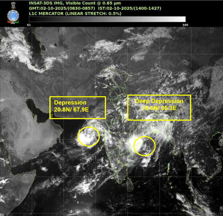
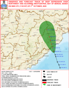
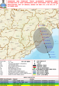
As per the IMD, a Deep Depression has developed over the northwest and adjoining west-central Bay of Bengal. This disturbance has been moving north-northwestwards at a speed of 18 km/h and is currently located at approximately latitude 18.6°N and longitude 85.3°E, close to the Odisha coastline. The system is expected to continue moving in the same direction and is likely to make landfall along the coasts of Odisha and Andhra Pradesh near Gopalpur between 12:00-15:00 UTC on 2nd October.
Key Details:
- Location at 0600 UTC on 2nd October 2025: 18.6°N, 85.3°E
- Maximum Sustained Wind Speed: 55-65 km/h, gusting to 75 km/h
- Sea Condition: Very rough to rough conditions are expected over the affected areas.
 Impact of the Bay of Bengal Cyclone:
Wind and Sea Conditions: As the Deep Depression continues its path north-northwest, squally winds reaching 55-65 km/h gusting to 75 km/h are expected to affect the west-central and northwest Bay of Bengal, as well as the coastal regions of Andhra Pradesh, Odisha, and West Bengal. The sea conditions will remain rough to very rough until 3rd October, making it hazardous for maritime activities, including fishing operations.
Fishermen Warnings: Fishermen are strongly advised against venturing into the west-central and northwest Bay of Bengal and the adjoining coasts of Andhra Pradesh and Odisha until 3rd October. The rough seas can pose serious risks to small boats and fishing vessels.
Coastal Effects: The cyclone’s landfall in Odisha and Andhra Pradesh could lead to localized flooding, coastal erosion, and infrastructure damage due to strong winds and heavy rainfall. Areas like Gopalpur, Puri, and Visakhapatnam are expected to experience intense weather conditions. The system is likely to weaken as it moves inland, but the initial impact could be significant for coastal communities.
Forecast and Intensity:
Based on the current forecast from the IMD, the system is expected to weaken after its landfall. By 3rd October, the system is forecasted to downgrade to a depression with wind speeds reducing to 40-50 km/h gusting to 60 km/h. However, it is important to monitor any changes in the intensity as cyclonic disturbances can often intensify or weaken unexpectedly.
Forecast Track:
02.10.25 (0600 UTC): 18.6°N, 85.3°E
02.10.25 (1200 UTC): 19.2°N, 85.1°E
03.10.25 (0000 UTC): 20.4°N, 84.7°E
03.10.25 (1800 UTC): 22.2°N, 84.0°E
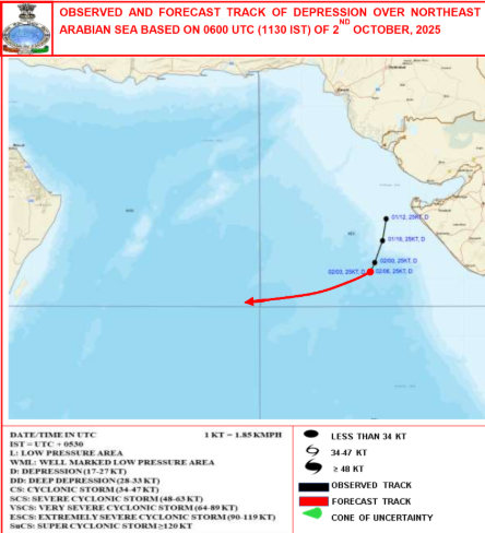
Cyclonic Disturbance in the Arabian Sea
In the Arabian Sea, another depression has formed over the northeastern region, located near 20.8°N and 67.9°E. This system is currently stationary but is expected to move southwestwards towards the central Arabian Sea over the next three days. The depression has a central pressure of 1001 hPa and is characterized by scattered to broken low and medium clouds, with embedded convection in the region.
Key Details:
Location at 0600 UTC on 2nd October 2025: 20.8°N, 67.9°E
Maximum Sustained Wind Speed: 40-50 km/h gusting to 60 km/h
Sea Condition: Very rough to rough conditions are anticipated over the northeast Arabian Sea and adjoining areas of the northwest Arabian Sea and along the North Gujarat coast.
Impact of the Arabian Sea Depression:
Wind and Sea Conditions: The depression is expected to bring squally winds of 40-50 km/h gusting to 60 km/h to the northeast Arabian Sea and the north Gujarat coastline. As the system moves southwestward, wind speeds will gradually decrease, but the sea conditions will remain rough to very rough along the North Gujarat coast and parts of the central Arabian Sea.
Fishermen Warnings: Fishermen are advised not to venture into the northeast Arabian Sea, especially along the Gujarat coast, until 3rd October. With rough seas expected in the region, it is essential for maritime workers to exercise caution and avoid open sea travel during this period.
Coastal Effects: The depression over the Arabian Sea could cause localized impacts along the western coastline of India, particularly in Gujarat. The rough seas, coupled with squally winds, may lead to coastal flooding and erosion in some areas, especially near Kutch and Saurashtra. The system is expected to weaken gradually but could still bring some adverse weather conditions in the coming days.
Key Preparedness Measures for Coastal Communities:
Evacuation and Shelter: Coastal communities in Odisha, Andhra Pradesh, Gujarat, and Maharashtra should be prepared for potential evacuation if necessary. Emergency shelters should be equipped to accommodate displaced populations.
Strengthening Infrastructure: It is essential to ensure that buildings, roads, and bridges are built to withstand high winds and heavy rains. Coastal barriers, such as seawalls and embankments, should be reinforced to protect vulnerable infrastructure.
Coastal Management: Ensuring proper coastal management, including the restoration of mangroves and other natural barriers, can help mitigate the impact of storm surges and flooding. These natural buffers are vital in reducing coastal erosion and protecting the environment.
Public Awareness and Communication: Governments should disseminate regular updates through media channels, mobile apps, and emergency broadcasting systems to keep people informed about the cyclonic developments and safety protocols. Public awareness campaigns can help people understand the risks associated with cyclones and take appropriate action in case of an emergency.
Long-Term Impact of Cyclones in the Region:
Cyclones in the Bay of Bengal and Arabian Sea have long-term impacts on the affected regions. Apart from the immediate destruction caused by strong winds, heavy rainfall, and storm surges, these systems can also lead to significant economic losses, especially in agriculture and fisheries. Moreover, coastal erosion and damage to infrastructure can disrupt the livelihoods of millions of people. In the coming years, as climate change continues to impact weather patterns, the intensity and frequency of cyclones may increase, making it even more critical to implement effective preparedness and mitigation measures.