Cyclone Ditwah has rapidly intensified into a formidable cyclonic storm brewing over the southwest Bay of Bengal, sending shockwaves of urgency across coastal Tamil Nadu as the India Meteorological Department (IMD) hoists the highest level red alert for multiple districts. With landfall predicted for the early hours of November 30, 2025, between north Tamil Nadu and south Andhra Pradesh coasts, this brewing monster could unleash sustained winds of 65-90 kmph gusting to 100 kmph, triggering flash floods, widespread power outages and potential structural damage in vulnerable low-lying areas.
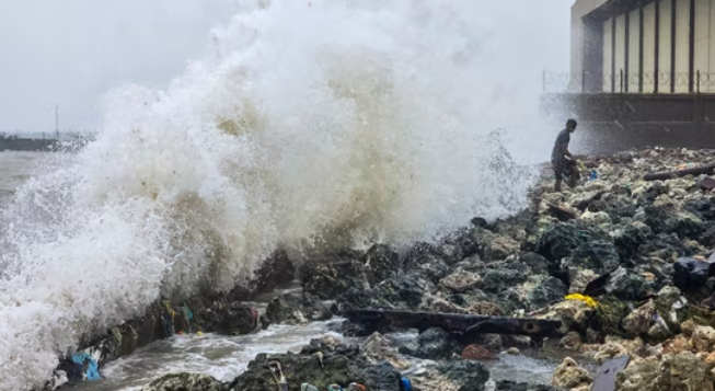
The storm, named by Yemen meaning “gentle breeze” in a cruel irony, has already ravaged Sri Lanka’s eastern coast, claiming nearly 100 lives and displacing thousands with relentless downpours and gale-force winds – a grim preview of what’s heading India’s way. As of November 29 morning, Ditwah lurks about 380 km south-southeast of Puducherry and 490 km south of Chennai, hurtling north-northwest at 7-8 kmph, fueled by warm sea surface temperatures that experts warn could spark rapid intensification overnight.
Tamil Nadu Chief Minister M.K. Stalin has activated the State Disaster Response Force, deploying over 20 relief teams and urging immediate evacuations from thatched huts and riverbanks in high-risk zones like Nagapattinam, Thanjavur, Tiruvarur and Pudukkottai, where extremely heavy rainfall exceeding 20 cm in 24 hours is forecast, rivaling the fury of last month’s Cyclone Fengal. Schools and colleges across delta districts stand shuttered today, exams postponed indefinitely, while Southern Railway cancels key trains and Chennai Airport braces for flight disruptions – IndiGo and Air India have issued travel advisories, rerouting dozens of flights amid swirling thunderstorms already lashing the coastline.
The IMD’s bulletin paints a dire picture: orange alerts blanket Chennai, Kancheepuram, Chengalpattu and Ranipet for very heavy rains on November 30, escalating to red for Cuddalore, Mayiladuthurai, Villupuram and Puducherry, where isolated spots could drown under 25 cm of rain, swelling rivers like the Coleroon and Cauvery to dangerous levels and sparking landslides in hilly pockets. NDRF’s eight elite teams, prepositioned from Arakkonam to Karaikal, stand ready with inflatable boats and thermal imagers for swift rescues, but officials stress that community vigilance is key – avoid beaches, secure loose objects and stockpile essentials like water, torches and first-aid kits to weather the onslaught.
What makes Cyclone Ditwah uniquely terrifying, according to climate researchers at IIT Madras, is its hybrid nature: born from a deep depression amplified by La Niña patterns, it’s not just a wind event but a moisture bomb capable of dumping a month’s rain in a day, exacerbating urban flooding in Chennai’s subways and lowlands – a scenario modeled after 2015’s Deluge 2.0 that paralyzed the city for weeks. Fishermen have been ordered to moor vessels inland since November 28, with signal No. 3 hoisted at ports from Tuticorin to Paradip, as rough seas whip up waves surging 3-5 meters high, threatening coastal erosion and saltwater breaches into farmlands.
In Puducherry, where memories of 2021’s Gati still sting, local administrations are airlifting supplies via IAF choppers, converting community halls into shelters for 50,000 at-risk residents, while Andhra Pradesh’s Nellore and Prakasam districts gear up for spillover effects with similar orange warnings. As the clock ticks towards landfall, satellite imagery from INSAT-3D reveals Ditwah’s tightening eye, a vortex of chaos swirling with lightning-laced clouds that could evolve into a severe cyclonic storm by dawn, packing a punch comparable to Odisha’s 2019 Fani in wind shear alone.
For real-time tracking, download the IMD’s ‘Meghdoot’ app or tune into DD News for hourly bulletins – every minute counts in outsmarting this tempest. Beyond the immediate peril, Cyclone Ditwah underscores a harsher truth: India’s eastern seaboard, warming faster than global averages per a 2025 World Bank report, faces a 30% spike in such events by 2030, demanding resilient infrastructure like mangrove buffers and early-warning radars to shield 150 million coastal lives. As Tamil Nadu hunkers down, global eyes watch: will advanced Doppler forecasts and AI-driven evacuations blunt Ditwah’s blow, or will it etch another scar on the cyclone-prone Coromandel?
Brace for impact! Cyclone Ditwah barrels towards Tamil Nadu with red alerts flashing – landfall hits November 30, unleashing fierce winds up to 100 kmph, flash floods & power cuts. Get live IMD updates, safety tips & evacuation routes to protect your family amid this monster storm threat. Don’t wait – act today!
Cyclone Ditwah, Tamil Nadu cyclone, IMD red alert, cyclone landfall 2025, Tamil Nadu heavy rain, Chennai cyclone update
Cyclone Ditwah tracker, Puducherry weather alert, Andhra Pradesh cyclone, NDRF evacuation, Sri Lanka cyclone damage
Hashtags: #CycloneDitwah #TamilNaduAlert #IMDWarning #CycloneLandfall #StaySafeTN #HeavyRainAlert #ChennaiStorm
(mausam.imd.gov.in), Tamil Nadu Disaster Management (tnsdma.tn.gov.in), NDRF updates (ndrf.gov.in), and recent Sri Lanka cyclone reports from BBC or Reuters
- https://theearthcurrent.com/category/earth-climate-change/
- https://theearthcurrent.com/category/science-and-space/
- https://theearthcurrent.com/category/world-affairs/
- https://theearthcurrent.com/category/sports/
- https://theearthcurrent.com/category/entertainment/
- https://theearthcurrent.com/category/artificial-intelligence/