As Cyclone Montha gathers strength over the Bay of Bengal India braces for a severe weather event set to slam the east coast on October 28 2025. Named by the India Meteorological Department (IMD) this cyclonic storm has already triggered heavy rainfall alerts across six states prompting mass evacuations school closures and NDRF deployments. In this comprehensive research-based analysis we track Montha’s rapid intensification explore its potential devastation draw from IMD forecasts and historical parallels and arm you with critical safety tips. Whether youre in the danger zone or following from afar this guide delivers real-time insights to keep you informed and prepared amid the chaos.
Current Status and IMD Forecast for Cyclone Montha
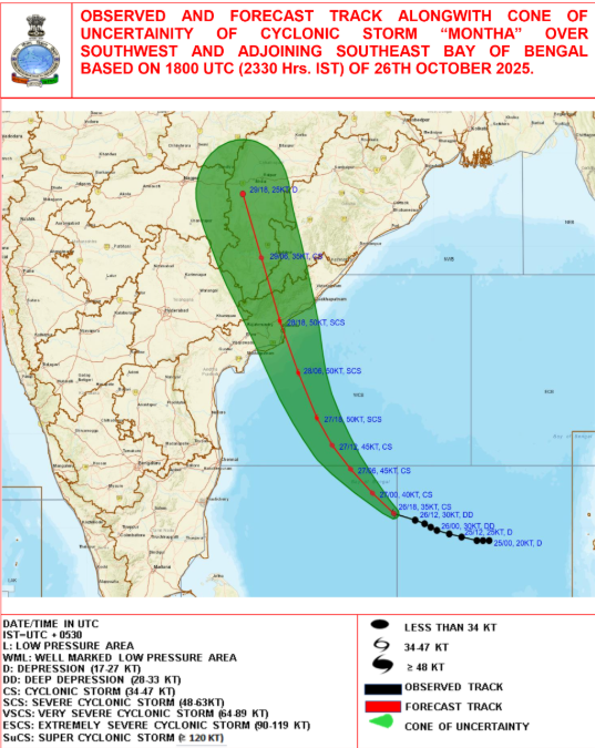
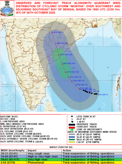
As of October 27 2025 morning the deep depression over the central Bay of Bengal has intensified into a cyclonic storm christened Montha located about 460 km southeast of Visakhapatnam. IMD predicts it will escalate to a severe cyclonic storm by October 28 morning with wind speeds reaching 90-110 kmph gusting to 120 kmph during landfall between Machilipatnam and Kalingapatnam near Kakinada in Andhra Pradesh. Heavy to very heavy rainfall is expected over Rayalaseema coastal Andhra Pradesh north Tamil Nadu south Odisha and Yanam with isolated extremely heavy falls on October 28-29. Moderate rains may extend to Arunachal Pradesh on October 29-30 while Telangana Kerala coastal Karnataka and interior Odisha face similar threats. Fishermen are urged to return to shore immediately as rough seas prevail with waves up to 4 meters high.
Formation Path and Why Montha is Intensifying Rapidly
Cyclone Montha formed from a low-pressure area that developed over the Andaman Sea on October 23 fueled by warm sea surface temperatures above 30°C and low wind shear conditions typical for post-monsoon cyclones in the Bay of Bengal. Its northwestward track mirrors historical storms like Hudhud (2014) which devastated Visakhapatnam but Montha’s faster intensification is linked to climate change-enhanced moisture convergence according to IMD experts. After crossing the Andhra coast it will weaken into a deep depression over north Andhra Pradesh and south Odisha by October 29 bringing continued downpours. Satellite imagery from INSAT-3D shows a well-defined eye forming signaling peak severity during landfall. This path threatens low-lying coastal areas with storm surges up to 2 meters potentially flooding Visakhapatnam Kakinada and Vijayawada.
Impacts and Affected Regions: Andhra Pradesh Odisha and Beyond
Andhra Pradesh faces the brunt with red alerts for nine coastal districts including East Godavari West Godavari Krishna and Guntur where gale-force winds could uproot trees damage infrastructure and disrupt power supplies. Odisha’s north coastal districts like Balasore Bhadrak and Mayurbhanj are on orange alert expecting heavy rains leading to flash floods and landslides. Tamil Nadu’s Chennai and Puducherry may see waterlogging while West Bengal’s southern districts brace for spillover effects. Economically fishing communities face losses estimated at ₹500 crore with ports like Paradip and Krishnapatnam suspending operations. Vulnerable populations in slums and coastal villages are at highest risk of displacement and health hazards from contaminated water.
Government Preparations and Evacuation Efforts
In a swift response Andhra Pradesh Chief Minister has ordered evacuation of over 1 lakh people from vulnerable areas deploying 22 NDRF teams and 150 SDRF personnel. Schools and colleges in coastal districts remain closed until October 29 while essential services like hospitals are on high alert with backup generators. Odisha has activated cyclone shelters stocked with food and medical supplies and banned fishing until November 1. The Indian Coast Guard is on standby for rescue operations using helicopters and vessels. Central government has released ₹200 crore in advance relief funds under the State Disaster Response Fund emphasizing early warning systems via the IMD’s mobile app and sirens. These measures build on lessons from Cyclone Fani (2019) reducing potential casualties through proactive drills.
Historical Context: Lessons from Past Bay of Bengal Cyclones
Montha joins a notorious lineage of Bay of Bengal cyclones which account for 80% of India’s tropical storms due to the region’s warm waters and geography. Comparable to Cyclone Amphan (2020) which caused ₹13,000 crore in damage or Yaas (2021) with 200 kmph winds Montha’s timing in late October aligns with peak cyclone season (October-December). Climate experts warn of increasing frequency with a 10-15% rise in severe cyclones since 2000 attributed to global warming. Past events underscore the need for resilient infrastructure like mangrove restoration which buffered impacts during Hudhud.
Essential Safety Tips: How to Stay Safe During Cyclone Montha
To navigate Montha’s fury secure loose objects indoors stockpile three days’ worth of non-perishable food water and medicines and avoid travel near coasts. If in a low-lying area head to the nearest cyclone shelter immediately following local authority alerts. Post-storm beware of fallen power lines contaminated water and aftershocks from flooding. Download the IMD app for hourly updates and keep emergency numbers handy: Police 100 Ambulance 108 NDRF 112. Community vigilance and early action can save lives remember preparedness turns peril into perseverance. As Montha approaches stay tuned for live updates and share this guide to spread awareness because knowledge is the ultimate shield against nature’s fury.
Track Cyclone Montha 2025 live updates IMD red alert Andhra Pradesh path impacts evacuation safety tips and forecasts for Odisha Tamil Nadu get real-time insights now
Cyclone Montha 2025 IMD alert Andhra Pradesh cyclone path heavy rain Odisha Tamil Nadu cyclone safety tips Bay of Bengal storm
Hashtags: #CycloneMontha #IMDAlert #AndhraPradeshCyclone #Cyclone2025 #WeatherUpdateIndia